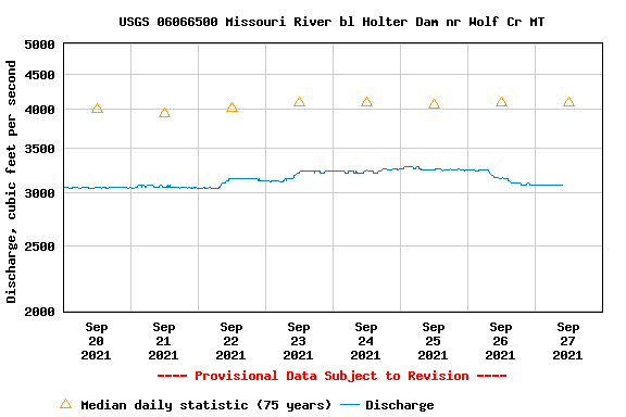
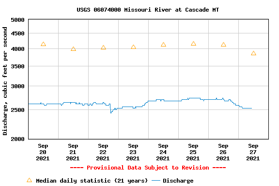
Hmmm. How do you account for this?
Are the USGS river gauges accurate?
3080cfs is what the Holter Dam gauge reads. 2530cfs is what the Cascade gauge reads.

Strange huh. Lower water downstream of Holter Dam. We have the Dearborn River coming in, Little Prickly Pear, and Sheep Creek. Albeit the lot of them does not add too much to the over all flows, but it does add approx 75 cfs.
So how can the river drop 15%+, lose flow, in the 35 miles between these two Mo River Flow Gauges?
Is USGS wrong. Giving us wrong info? Broken gauge? Lying to us about the real flows coming out of Holter Dam? Some fear the latter. And those with boots on the ground, those who have fished and lived here for a generation or better, believe the flows are lower than the 3Kcfs that the Holter Dam gauge reads.
Don’t know where you stand but we do know that the flows have not been this low since 2006. We didi emerge out fo the last drought of 2001-2007 quite well. The fish weathered well. Mother Nature does well.
2008-2011 we witnessed the highest trout populations on record here on the Mo, with those 4 years bringing lots and lots of water. If you remember the 4 high water years with flows hindering the dry fly bite in July and beyond. Flows near the 30K mark. Yep. Big water.
We do know that Mother Nature generally levels things out. That is what we are looking for here. In the future.
We are questioning the validity of either gauge now in regards to the 500 missing cubic feet/second. Where does it go? Very few still irrigating here on the Mo. If any. And, when they are irrigating the cfs draw from each pivot is 1 to 2cfs. Not much. So that cannot make up for the missing water.
Just an update here on your Missouri River information source. Keep it locked here for the up to date fishing reports, river info, fly suggestions, entertainment, and all thing Mother Mo.
Have a great Monday!


8 Comments.
The gauge has been wonky all summer. Trust the eyeball gauge over what the USGS is saying. My guess would be they are fudging numbers to avoid being fined for going below minimum stream flow.
Look at the stage on the gage and how it relates to flow now versus in the past. Gages don’t typically measure flow, they measure stage and there is a rating curve used to get flow from a given stage.
Although the gauges here in Montana do measure flow. And Gauge height.
Check out the following from USGS – while nearly all gages publish flow it is very rare that flow is actually measured, stage is measured and flow is computed. Interesting stuff! https://www.usgs.gov/mission-areas/water-resources/science/streamgaging-basics?qt-science_center_objects=0#qt-science_center_objects
The only place a true flow measurement can even be obtained is the dam. The rest of the river gauges rely on stage to correlate a cfs flow measurement from the rating curve. Maybe the rating curve is less accurate at these low flows? Either way something is weird. -500cfs to evaporation?
The govt lying to us on water? You mean like masks and vaccines? yea, believe it.
My Boat has been taking on more water than usual this year.
Can I walk across the river at 2500cfs? Excluding the bridges of course.